Embark on an enchanting journey through the finest beaches along North Carolina’s Coast! The adventure begins at the very top of the famous NC Outer Banks, specifically at the northernmost beach, Carova. This secluded haven is not only accessible by an exhilarating 6-mile 4×4 drive in the sand, but it’s also home to the famous wild horses that roam freely, adding to the magic of the landscape.
As you journey southward, you’ll uncover a series of breathtaking beaches that stretch all the way to the southernmost tip of the NC coast. For the intrepid travelers among you, be prepared to take a couple of ferry rides if you decide to traverse from beach to beach!
Each beach on this compelling list is accompanied by an Info Link, offering you photos and useful information about these coastal treasures. Additionally, to enhance your beach experience, we’ve included a Beach Access Map for each location. By clicking on these links, you’ll not only see a map of the beach access points, but also photos of these entrances, giving you a real sense of what to expect.
For those thirsting for a challenge, why not explore all the Outer Banks beaches? Located far out in the barrier islands of the Atlantic Ocean, these beaches offer an experience that is truly extraordinary. As you traverse this list, you’ll discover many of these beaches to be the most remote, tranquil, friendly, and incredibly exciting on the planet!
And, there’s more! You can drive on a significant portion of the Outer Banks beaches, making for the most thrilling beach vacation imaginable. So, buckle up and prepare for a coastal adventure that’s sure to create lifelong memories!
- Carova Beach – Info Link – Beach Access Map
- Corolla Beach – Info Link – Beach Access Map
- Duck Beach – Info Link – Beach Access Map
- Southern Shores Beach – Info Link – Beach Access Map
- Kitty Hawk Beach – Info Link – Beach Access Map
- Kill Devil Hills Beach – Info Link – Beach Access Map
- Nags Head Beach – Info Link – Beach Access Map
- South Nags Head Beach – Info Link – Beach Access Map
- Rodanthe Beach – Info Link – Beach Access Map
- Waves Beach – Info Link – Beach Access Map
- Salvo Beach – Info Link – Beach Access Map
- Avon Beach – Info Link – Beach Access Map
- Buxton Beach – Info Link – Beach Access Map
- Frisco Beach – Info Link – Beach Access Map
- Hatteras Beach – Info Link – Beach Access Map
- Ocracoke Beach – Info Link – Beach Access Map
- Portsmouth Island Beach – Info Link – Beach Access Map
- Atlantic Beach – Info Link – Beach Access Map
- Pine Knoll Shores – Info Link – Beach Access Map
- Indian Beach – Info Link – Beach Access Map
- Emerald Isle Beach – Info Link – Beach Access Map
- Hammocks Beach State Park – Info Link – Beach Access Map
- North Topsail Beach – Info Link – Beach Access Map
- Surf City Beach – Info Link – Beach Access Map
- Topsail Beach – Info Link – Beach Access Map
- Wrightsville Beach – Info Link – Beach Access Map
- Carolina Beach – Info Link – Beach Access Map
- Kure Beach – Info Link – Beach Access Map
- Fort Fisher State Recreation Area – Info Link – Beach Access Map
- Bald Head Island – Info Link – Beach Access Map
- Oak Island – Info Link – Beach Access Map
- Caswell Beach – Info Link – Beach Access Map
- Holden Beach – Info Link – Beach Access Map
- Ocean Isle Beach – Info Link – Beach Access Map
- Sunset Beach – Info Link – Beach Access Map
- Bird Island Reserve – Info Link – Beach Access Map
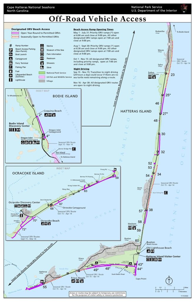
The following shows off road vehicle access (Beach Driving) at the Cape Hatteras National Seashore. This does not include Beach driving opportunities at Kill Devil Hills, Corolla, or Carova Beaches.

Here is a list of the ORV (Off-Road Vehicle) beach access points along the Outer Banks of North Carolina, organized by location and mile marker (where applicable):
Corolla:
1. Corolla Beach Access Ramp (Mile Post 13)
Carova:
2. Carova Beach Access (4WD only, no mile marker)
Nags Head:
3. Coquina Beach (Mile Post 22)
4. Oregon Inlet (Mile Post 32)
Hatteras Island:
5. Ramp 4 (Mile Post 38)
6. Ramp 23 (Mile Post 43)
7. Ramp 27 (Mile Post 46)
8. Ramp 30 (Mile Post 49)
9. Ramp 34 (Mile Post 52)
10. Ramp 38 (Mile Post 55)
11. Ramp 43 (Mile Post 58)
12. Ramp 44 (Mile Post 59)
13. Ramp 45 (Mile Post 60)
14. Ramp 49 (Mile Post 62)
15. Ramp 55 (Mile Post 67)
Ocracoke Island:
16. Ramp 59 (Mile Post 70)
17. Ramp 67 (Mile Post 75)
18. Ramp 70 (Mile Post 77)
19. Ramp 72 (Mile Post 79)
Please note that access to some ramps may be restricted seasonally due to wildlife protection or other factors. It’s always a good idea to check with the local authorities or the National Park Service for the most up-to-date information on beach access and any necessary permits before planning your trip.
